Scientists warn there is now an 80% chance that an El Niño will occur between June and August, increasing the risk of extreme heat and related weather events.
“Fueled by unusually warm waters in the tropical Pacific, El Niño is developing and will affect global temperature and rainfall patterns,” the UN’s weather and climate agency said on Tuesday.
The Geneva-based World Meteorological Organization said forecasts from its global network “point to a clear shift to El Niño, with an 80% chance of June to August”.
Also on AF: Pacific nations climate fund tied to fossil fuels
El Niño is a natural climate phenomenon that increases sea surface temperatures in the central and eastern equatorial Pacific Ocean, causing global changes in wind, pressure and rainfall patterns.
It usually takes place every two to seven years and lasts about nine to twelve months. Conditions oscillate between El Niño and the opposite La Niña, with neutral conditions in between.
The World Meteorological Organization said in its quarterly El Niño/La Niña update that the likelihood of an El Niño event by November is “near or greater than 90%,” with most forecast models indicating that El Niño will be “at least mild and likely to be strong.”
World Meteorological Organization chief Celeste Solo said the world needed to prepare for a strong El Niño, which could “exacerbate droughts and heavy rainfall and increase the risk of heat waves on land and in the oceans”.
The World Meteorological Organization says even a mild El Niño will make some extreme weather and climate conditions more likely.
Trade and economy face risks
The World Meteorological Organization said “above normal temperatures are expected in almost all parts of the world” from June to August.
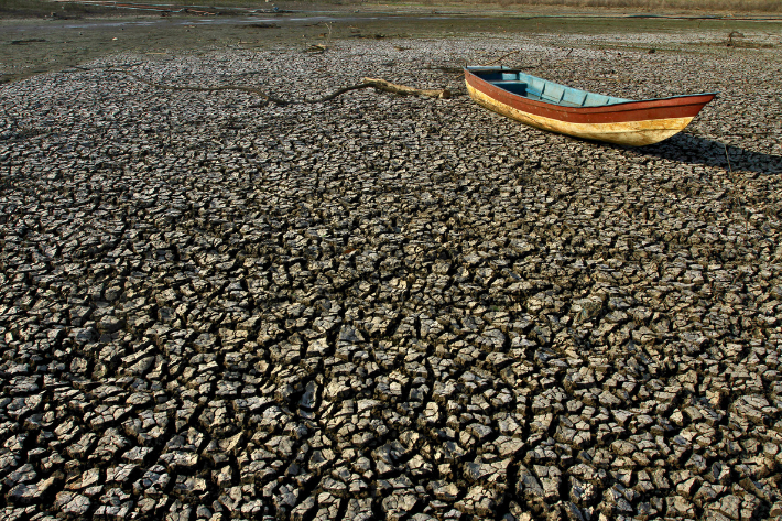
This increases the risk of compound disasters in some areas and accelerates the onset of drought conditions with reduced rainfall, the report said.
Salo said El Niño would have “knock-on effects” with warming tropical oceans affecting global trade.
The issues concern “climate change, the economy and people’s security. That’s why this information is so relevant and so important,” she told reporters.
Saulo said other risks associated with extreme heat include wider spread of diseases borne by vectors such as mosquitoes and ticks and reduced food and water supplies.
“Already struggling communities will be pushed further to their limits,” she said.
The World Meteorological Organization hopes that early warnings can guide disaster preparedness, especially in climate-sensitive areas such as agriculture, water management, energy and health.
The Regional Climate Center predicts “below normal” rainfall during the key June-September rainy season in the northern Horn of Africa; below-average monsoon rainfall in South Asia; and drier and warmer summer conditions in Central America.
During the Northern Hemisphere summer, warm water associated with El Niño may fuel hurricanes in the central and eastern Pacific while hindering hurricane development in the Atlantic.
Call for climate action
The World Meteorological Organization says there is no evidence that climate change will increase the frequency or intensity of El Niño events.
However, the agency believes this could amplify the impacts, as ocean and atmospheric warming increases the availability of energy and moisture to cope with extreme weather events such as heat waves and heavy rainfall.
“El Niño is coming,” U.N. Secretary-General Antonio Guterres said in a video address.
“The world must treat this as an urgent climate warning. El Niño will add fuel to the fire of global warming.
“The only effective response is climate action that confronts the crisis – ending our dependence on fossil fuels, accelerating the shift to renewable energy, protecting the most vulnerable and providing early warning systems for all.”
Solow said that currently 128 countries have established multi-hazard early warning systems, and the United Nations aims to achieve full coverage by the end of 2027.
Waiting for more data
While El Niño typically peaks between November and February, the resulting temperature spike often occurs later in the year.
Forecasts for next month are likely to be more accurate regarding the onset of El Niño and its intensity. The World Meteorological Organization said the intensity of El Niño is still uncertain due to varying severity among models.
The World Meteorological Organization stated that from late April to mid-May, the sea surface temperature in the central and eastern equatorial Pacific as a reference for monitoring was close to the El Niño threshold, and the subsurface temperature was more than 6 degrees Celsius higher than the average.
At the same time, the Southern Oscillation Index – the atmospheric component of El Niño – is also consistent with the development of this phenomenon.
The last El Niño event made 2023 the second-warmest year on record and 2024 the warmest on record, about 1.55 degrees Celsius above the pre-industrial average of 1850-1900.
- AFP, with additional editing and input by Vishakha Saxena